CI4Clouds – Computationalö Intelligence for Cloud Masking
Short Description
Numerous satellites orbit the Earth, permanently producing observational data from various instruments. One example for such instruments is the group of optical sensors.
Optical sensors measure the sunlight reflected by the Earth, recording images in the spectral range from near-UV to near-IR. Clouds present a problem when observations of the surface or clear air are required. Thus, measurements have to be classified according to whether clouds are present or not – a cloud mask. A typical application of satellites involves the derivation of geophysical parameters.
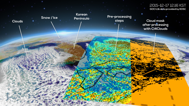
An example is the Geostationary Ocean Color Imager (GOCI). It observes the region of Korea, Japan, and East-China in the visible spectral region. Its main purpose is to recognize different properties of the ocean surface (algal blooms, gelbstoff, and other particles), and is thus not ideal for detecting clouds. Another example is the Sentinel-4 instrument of the Copernicus program, which will be started in 2019 to measure the air quality over Europe.
In the CI4Clouds project, the latest Machine Learning algorithms will be evaluated in their ability to produce a reliable cloud mask based on GOCI data. Models for the cloud mask will be trained and their pre- and post-processing steps optimized. The results will be compared to those acquired from instruments specialized in cloud detection. The objective is to obtain comparable results despite GOCI not being designed for cloud detection.
Every Machine Learning approach relies heavily on a set of representative training data describing all relevant scenarios. In the given domain the data must cover different types of clouds and landscape, times of day and year, intensity of light, or translucence of clouds. For the training phase, powerful parallel hardware will be available to handle the huge amounts of data efficiently.
An outcome of this project will be an improved cloud mask for those satellites which only use optical sensors. This product shall then be integrated into existing products, such as for aerosol or surface recognition, and be offered to the scientific community and for forecasting purposes.
Project Partners
- Catalysts GmbH
- Zentralanstalt für Meterologie und Geodynamik (ZAMG)
Contact Address
Bernhard Niedermayer
E-Mail: bernhard.niedermayer@catalysts.cc